Celebrate Big Bend National Park's Anniversary
Robert DeckerEstablished June 12th, 1944, Big Bend National Park is a stunning testament to the rugged beauty and biological richness of the American Southwest. Located in a remote corner of Southern Texas along 118 miles of the Rio Grande, the park preserves the largest protected area of Chihuahuan Desert topography and ecology in the United States. With its diverse plant and animal life, breathtaking geological formations, and deep cultural history, Big Bend remains one of the nation’s most extraordinary and least visited national parks.
Table of Contents
- Chihuahuan Desert Ecology and Biodiversity
- Establishment of Big Bend National Park
- Human History and Cultural Legacy
- Santa Elena Canyon and the Rio Grande
- Binational Conservation Efforts
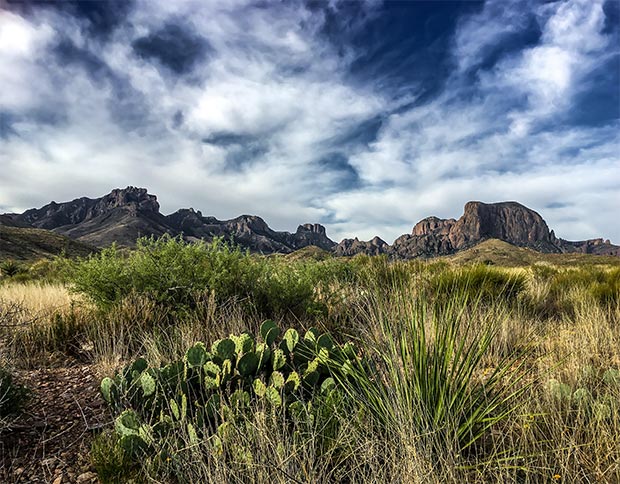
Chihuahuan Desert Ecology and Biodiversity
Big Bend National Park encompasses 801,163 acres and boasts more than 1,200 species of plants, over 450 species of birds, 56 species of reptiles, and 75 species of mammals. Its varied elevation—from river valleys to the Chisos Mountains—creates a range of microclimates, contributing to this ecological diversity. The park is home to desert flora like ocotillo and prickly pear, as well as forested mountain slopes with pinyon pines and junipers. Bird species such as the Colima warbler, golden eagle, and vermilion flycatcher are commonly spotted here, and large mammals include black bears, mountain lions, and mule deer.
Establishment of Big Bend National Park
The idea of preserving this remote region as a national park dates back to the early 20th century. Texas officially acquired land for the park and donated it to the federal government in 1933. After years of advocacy and planning, Congress established Big Bend National Park in 1944, during the final years of World War II. It became the first Texas national park and one of the few parks established during wartime. The park’s creation protected a largely undeveloped and ecologically sensitive area, safeguarding it from ranching, mining, and uncontrolled development.
Prior to the park’s establishment, the region was inhabited by Native American tribes, followed by Spanish explorers, Mexican settlers, and Anglo-American ranchers. Old ranching outposts and mining ruins can still be found throughout the park, offering glimpses into the lives of early inhabitants and homesteaders.
Human History and Cultural Legacy
Artifacts found in the park date back more than 9,000 years, showing that the region has long been home to indigenous peoples who hunted and traveled through the Chihuahuan Desert. These early cultures left behind stone tools, rock art, and traces of seasonal camps.
In the 19th century, the Rio Grande corridor became a vital route for commerce and settlement. Historic adobe buildings, military outposts, and irrigation systems still stand today as symbols of the cross-border cultural exchange that has shaped the region. The park also contains significant paleontological resources, including fossils from the Cretaceous and Cenozoic eras that tell the story of the park’s ancient seas and dinosaur inhabitants.
Santa Elena Canyon and the Rio Grande
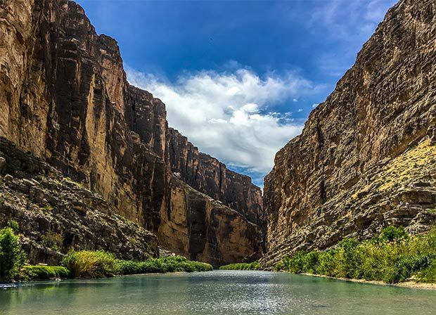
One of the most iconic landmarks in Big Bend is Santa Elena Canyon, where limestone walls rise 1,500 feet above the Rio Grande. Split down the middle by the river, one side lies in the United States, and the other in Mexico. The canyon offers a dramatic and picturesque landscape that is accessible by boat or on foot via the Santa Elena Canyon Trail.
The Rio Grande serves as an international boundary and a lifeline for many desert species. Because of this, Big Bend faces unique challenges in managing cross-border issues, such as wildlife migration, invasive species, and river health. Visitors often experience the awe-inspiring contrast between the lush riverbanks and the surrounding arid terrain.
Binational Conservation Efforts
Because the Rio Grande marks the international boundary, Big Bend National Park shares its southern border with two protected Mexican areas: Parque Nacional Cañon de Santa Elena and Maderas del Carmen. Together, these three parks form one of the largest binational conservation regions in North America.
Established under the principles of the Treaty of Guadalupe Hidalgo, the U.S. territory of the park extends only to the middle of the deepest river channel, as it existed in 1848. This legal and geographical complexity requires strong international cooperation in matters of land stewardship, conservation, and visitor safety. Efforts to establish a formal U.S.–Mexico "International Peace Park" continue today, as part of a broader vision to protect the cultural and ecological heritage of this region.
 Click here to see the Big Bend National Park poster.
Rob Decker is a photographer and graphic artist who had the rare privilege of studying under Ansel Adams in Yosemite National Park when he was just 19 years old. Now, Rob is on a journey to explore and photograph all of America’s National Parks. He’s creating WPA-style posters to help people celebrate their own national park adventures — as well as encourage others to get out and explore!
Click here to learn more about the artist, Rob Decker...
Join the growing community of 125k+ National Park enthusiasts to receive insider deals and updates.