Best Things to do in Yellowstone National Park (Part 2)
Robert DeckerWith a history spanning millions of years and geology that will awe and inspire even the most unimpressionable visitor, the areas of Yellowstone’s Grand Canyon and Lower Yellowstone River will leave you breathless – both literally and figuratively!
My name is Rob Decker and I’m a photographer and graphic artist with a single great passion for America’s National Parks! There is so much to see and do throughout Yellowstone, it’s easy to get overwhelmed – best to take it in stages. This Part 2 article in our 3-part Yellowstone National Park series focuses on the Grand Canyon and lower parts of the park.
Yellowstone’s Grand Canyon
This area should be top-of-the-list for any visitor to Yellowstone for one simple reason: The Grand Canyon of the Yellowstone.

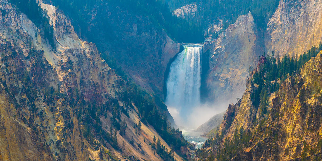
If one were to fly high above, what may seem like a loose seam in the fabric of the Earth is actually a 20-mile-long split – a gorge that plummets from a sheer-sided fissure more than 1,000 feet down to the Yellowstone River. In certain places, it widens up to 4,000 feet. Two thundering waterfalls punctuate the river’s flow in a palette of bright yellows, oranges, reds, whites, and browns swirling across the rocky depths. A whopping 63,500 gallons of water per second runs through these falls at its peak, then gradually drops to as low as 5,000 gallons per second come late fall.
It’s no wonder this area has been the muse of countless artists over the decades. And while this canyon is not nearly as big as the one in Arizona, it is just as impressive. Several miles of hiking trails connect 10 major overlooks, affording dramatic views from both sides of the canyon.
Lower Falls of the Yellowstone River
The lower falls owe their existence to bands of hard volcanic rock. These bands did not erode as quickly as the surrounding softer stuff; consequently, the more resistant spots formed dramatic drops over which the raging river plummets, with dramatic effect. The colors continue throughout, made possible by the minerals taking up residence in the rock, such as iron in the rhyolite. Different layers of rock are exposed, and varying stages of oxidation transform the surrounding cliffs into wonderful hues.

The trail hiking in this area is amazing. The Brink of Lower Falls Trail in the North Rim, in particular, offers a gorgeous vantage point and a peek at the 109-foot Upper Falls near the top. While this is a short mile-long hike and paved, it does dip 600 feet to a precarious perch above a 308-foot waterfall. Alternatively, Lookout Point offers a wider perspective of the Lower Falls, and you may just get a glimpse at an osprey nesting site!
Continue down to the Red Rock Trail – a boardwalk staircase going down 500 feet deep into the canyon. Here, the Grand View Overlook points downstream for a kaleidoscope view of vibrant canyon colors. The last view on this trail is Inspiration Point, giving an astounding glimpse of the Lower Falls and the canyon downstream.
Drive to the South Rim, and you can access Uncle Tom’s Trail; a steep, switch-backing route consisting of a steel staircase bolted right into the side of the canyon. Back in the day, this trail was nothing more than a rope ladder. For something a little easier, take 1.3-mile Point Sublime Trail. Follow the South Rim Trail beyond Artist Point to this less-traveled path, which meanders along the canyon rim.
Conversely, for those seeking something more strenuous, the Seven Mile Hole Trail is the only one that leads to the canyon bottom. You’ll want to commit an entire day to this incredible hike, at just over 10 miles round trip. You’ll also want to pack a picnic lunch and stop frequently along the way just to admire the views.
Several of these canyon trails were originally built in the 1930’s and efforts are underway to rehabilitate some of them with support from Yellowstone Forever. Due to unforgiving weather, soil erosion, and increased visitation, they have been hammered over the years and the park is dedicated to maintaining the safety and beauty of these trails.
Mount Washburn
For a great day-hike just a few miles north of Canyon Village, Mount Washburn is the result of volcanic activity that took place long before the formation of today’s canyon. Named after General Henry Washburn, who was a leader of the 1870 Washburn-Langford-Doane Expedition, the mountain stretches up to 10,243 feet (3,107 meters) and has panoramic views at the summit for up to 50 miles on a clear day.

While at the top, don’t miss out on interpretive exhibits. The mountain is one of three fire lookout stations in Yellowstone and is fully staffed with park rangers watching for signs of fire all throughout fire season from about mid-June through early autumn.
View Wildlife in Hayden Valley
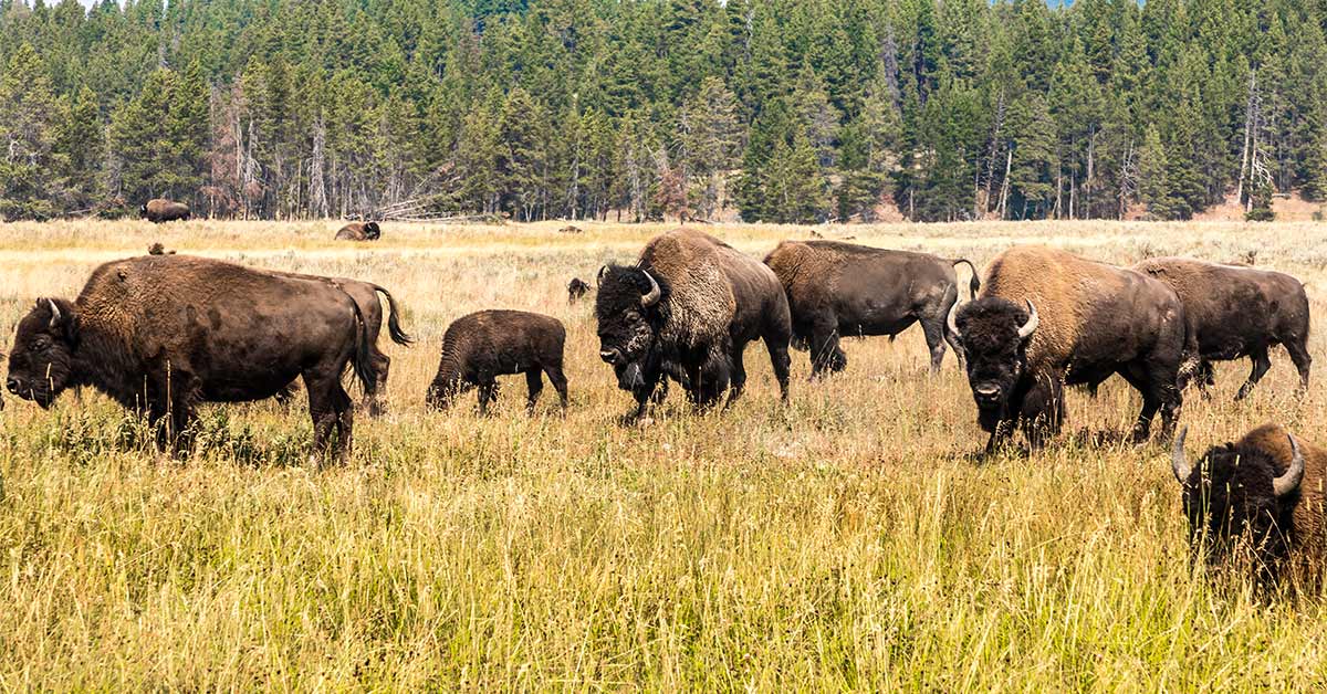
Hayden Valley is located six miles north of Fishing Bridge Junction. Hayden Valley offers some of the best habitat in the lower 48 states for viewing wildlife like grizzly bears, bison, and elk. Hayden Valley was once filled by an arm of Yellowstone Lake and it contains fine-grained lake sediments that are now covered with glacial till left from the most recent glacial retreat, about 13,000 years ago. Because the glacial till contains many different grain sizes, including clay and a thin layer of lake sediments, water cannot percolate readily into the ground. This is why Hayden Valley is marshy and has little encroachment of trees. Stay tuned for the next installment of Best Things to do in Yellowstone National Park!
Canyon Village
This area of Yellowstone provides the perfect base for exploring the canyon. The village could be considered a small town unto itself; a sprawling development with lodging, dining options, a general store, a campground, and the Canyon Visitor Education Center. The Canyon Lodge and Cabins are probably the most centrally located within Yellowstone, for easy travels north to popular spots like Mammoth Hot Springs and Lamar Valley, as well as points south and west.
Canyon Visitor Education Center
Located in Canyon Village, this is a great place for an introduction to your upcoming adventures. It was part of the Mission 66 project, a 10-year effort intended to expand Park Service visitor services by 1966 in time for the 50th anniversary of the establishment of the Park Service. Learn about the geology, history, and wildlife of Yellowstone’s Grand Canyon.
Also, learn about Yellowstone’s supervolcano and how it affects the landscape. Check out the 9,000-pound rotating “kugel ball” that illustrates global volcanic hotspots, along with the world’s largest lava lamp! View exhibits, a 3D map, and see reenactments of the major eruption at Yellowstone 640,000 years ago. Watch an informative film in the theatre, and listen in as rangers give real-time information about park happenings.

Click here to see the Lower Falls poster.
Rob Decker is a photographer and graphic artist with a single passion for our National Parks! Rob is on a journey to explore and photograph each of our national parks and to create WPA-style posters to celebrate the amazing landscapes, vibrant culture and rich history that embody America's Best Idea!
Click here to read more about Yellowstone's Geyser Basin and Old Faithful!
Click here to learn more about the artist...
Join the growing community of 80k+ National Park enthusiasts to receive insider deals and updates.