Best Things To Do at Golden Gate National Recreation Area
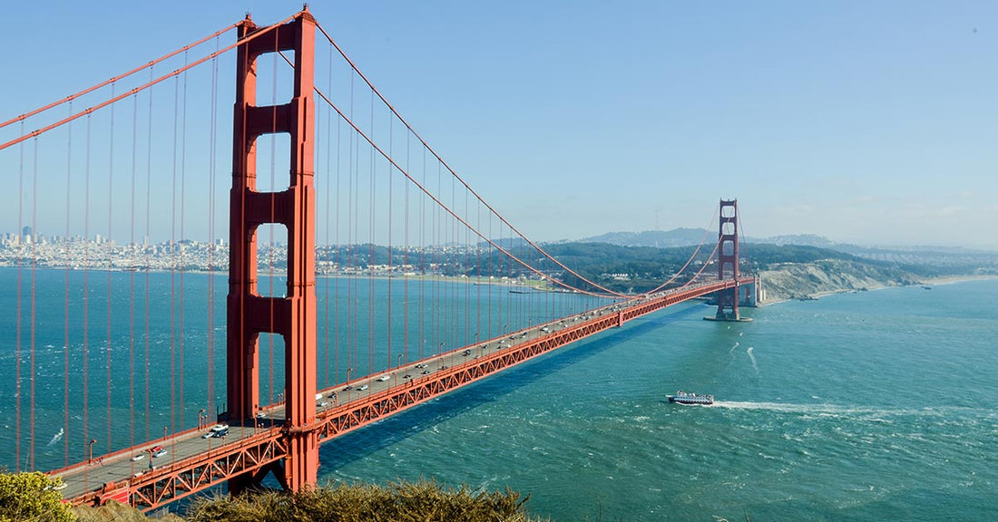
Robert DeckerStraddling both sides of the Golden Gate Bridge, Golden Gate National Recreation Area (GGNRA) protects more than 80,000 acres of beaches, headlands, redwood groves, and historic forts—making it one of the world’s largest urban national park sites. Spread across the San Francisco Bay Area, this remarkably diverse landscape blends natural riches with military history: think the windswept Marin Headlands, cliff-hugging trails at Lands End, the brick ramparts of Fort Point, the lighthouse at Point Bonita, the expansive sands of Ocean Beach, the cultural landscapes of the Presidio, and nearby old-growth redwoods at Muir Woods National Monument.
Administered by the National Park Service and welcoming millions of visitors each year, GGNRA is a year-round escape for hiking, photography, wildlife watching (raptors, seabirds, migrating whales), and iconic views of the bridge and bay—easily reached by car or public transit. This guide covers the best things to do, top trails and viewpoints, and practical tips for planning your visit to Golden Gate National Recreation Area.
My name is Rob Decker and I’m a photographer and graphic artist with a single great passion for America’s national parks! I’ve been to 55 of our 63 national parks — and Golden Gate National Recreation Area is one of my personal favorites — having grown up in the San Francisco Bay Area. With 37 distinct park sites, from Muir Woods National Monument to Fort Point National Historic Site to Alcatraz Island, more than 130 miles of trails, and 1,200 historic structures, Golden Gate National Recreation area truly has something for everyone! If this is your first time to the San Francisco Bay Area, or your returning after many years, here are some of the best things to do in Golden Gate National Recreation Area!
Marin County (North of Golden Gate Bridge)
Fort Baker
Fort Baker is a 335 acre former 1905 U.S. Army post located immediately north of the Golden Gate Bridge. This hidden gem of a site consists of over 25 historic army buildings clustered around a main parade ground, a sheltered harbor protected by a jetty, a number of historic gun emplacements, and trails and forested areas climbing gently up from San Francisco Bay.
Headlands Center for the Arts
The Headlands Center for the Arts is an artist residency program set in renovated military buildings in the Marin Headlands. Offers programs including performances, discussions and lectures, and displays a 1,800-square-foot project space with a rotating roster of artists open to the public.
Marin Headlands
 Here you can discover the many cultures that have called the Marin Headlands home, from the Miwok Indians to the American Military and everything in between. Enjoy a hike through its varied trails, including dog-friendly Rodeo Beach, or visit The Marine Mammal Center, Rodeo Lagoon, Muir Beach, Tennessee Valley and the Gerbode Valley. Take a drive along Conzelman Road from the northern foot of the Golden Gate Bridge to Point Bonita. This five-mile road offers breathtaking views of San Francisco and the Pacific Ocean.
Muir Woods National Monument

Walk among old growth coast redwoods, cooling their roots in the fresh water of Redwood Creek and lifting their crowns to reach the sun and fog. Federally protected as a National Monument since 1908, this primeval forest is both refuge and laboratory, revealing our relationship with the living landscape. You'll also see Coast Douglas-fir, Bigleaf Maple, Tanbark Oak, and California Bay Laurel.
Oakwood Valley
On a clear day you can see as far as Point Reyes from this park adjacent to the Marin Headlands. Trails loop through groves of eucalyptus and bay laurel. In the spring you will find lupine and California poppies. In summer, the grasses turn golden, and by late summer you can find fennel, sagebrush, and blackberry bushes. Oakwood Valley contains the largest untouched woodland of Coast Live Oak and California bay trees in the Golden Gate National Recreation Area.
Olema Valley
Olema Valley is a rolling landscape of grassland and forest a ten mile stretch from Tomales Bay to Bolinas Lagoon. This area has been shaped by geologic forces and changing patters of human use. Until recently, the dynamic story of the valley remained largely undiscovered. Now, steps are underway to preserve both the history and fragile beauty of this northern corner of the park.
Point Bonita Lighthouse

A secret jewel of the Bay Area, the Point Bonita Lighthouse, built in 1855, was the third lighthouse built on the West Coast and helped shepherd ships through the treacherous Golden Gate straits. Today, the lighthouse is still active and is maintained by the U.S. Coast Guard. Discover Point Bonita's wild landscape, geology and fascinating history by hiking the trail to the Point Bonita Lighthouse!
Stinson Beach

Stinson Beach is one of Northern California’s best kept secrets. It’s located about 20 miles NW of San Francisco alongside Mt Tamalpais State Park. Being only a 35 minute trip from the Golden Gate Bridge, Stinson Beach is a very popular day trip for residents and tourists alike. With opportunities for volleyball, hiking, picnicking, fishing, or surfing, people continue to visit Stinson Beach to escape from the frantic pace of everyday life, just they have been doing for more than a century.
Muir Beach Overlook

Muir Beach Overlook provides expansive views of the Pacific Coast, including the Point Reyes Peninsula. Visitors can also explore several historic base-end stations, observation posts that were part of the San Francisco Bay coastal defense system. From this vantage point soldiers could view ships through telescopes, and plot their distance, speed, and direction in order to aim nearby coastal defense guns that protected the area from invading warships in the 1900s.
Fort Cronkhite
Located in the Marin Headlands north of Rodeo Lagoon, Fort Cronkhite is a former World War II military post that stands at the edge of the Pacific Ocean. Fort Cronkhite is one of the few examples of these World War II "mobilization posts" remaining in the country. The fort's barracks, mess halls, and other structures are preserved to tell the story of the soldiers who waited here for an enemy that never came. Today, Fort Cronkhite's buildings are used as offices and housing for the National Park Service and its park partners.
Nike Missile Site SF-88
SF-88 is a decommissionedArmy surface-to-air missile (SAM) site located near Fort Barry, in the Marin Headlands to the north of San Francisco, California. Opened in 1954, the site was intended to protect the population and military installations of the San Francisco Bay Area during the Cold War, specifically from attack by Soviet bomber aircraft.
San Francisco County (South of Golden Gate Bridge)
Alcatraz Island

Alcatraz reveals stories of American incarceration, justice, and our common humanity. This small island was once a fort, a military prison, and a maximum security federal penitentiary. In 1969, the Indians of All Tribes occupied Alcatraz for 19 months in the name of freedom and Native American civil rights. Here you can explore Alcatraz's complex history and natural beauty.
China Beach
China Beach is in a tiny cove tucked between Lands End and Baker Beach in the Sea Cliff neighborhood of San Francisco. This sheltered pocket of sand features a picnic area, sunbathing, good play spots for children, and spectacular views of the Marin Headlands and Golden Gate.
Fort Funston

Fort Funston features 200-foot high sandy bluffs on San Francisco’s southwest coast where the winds blow reliably wildly. No surprise it is one of the premier hang-gliding spots in the country. A network of trails make it ideal for hiking and horseback riding. Dog owners will be happy to know they can take leashes off here. It is also home to the Fort Funston Native Plant Nursery.
Fort Mason
Once known as San Francisco Port of Embarkation, this former United States Army post located in the northern Marina District, alongside San Francisco Bay. Fort Mason served as an Army post for more than 100 years, initially as a coastal defense site and subsequently as a military port facility. During World War II, it was the principal port for the Pacific campaign. The National Historic Site now houses non-profit organizations and offers a variety of cultural activities.
Fort Miley Military Reservation
The Fort Miley Military Reservation, sits on Point Lobos (not to be confused with Point Lobos near Carmel-by-the-Sea), one of the outer headlands on the southern side of the Golden Gate. The grounds and buildings have been converted into the San Francisco VA Medical Center are administered by the Veterans Health Administration of the US Department of Veterans Affairs.
Lands End
At every turn of the trail on this wild and rocky northwestern corner of San Francisco, there is another stunning view. Along the way you’ll see hillsides of cypress and wildflowers, views of old shipwrecks, access to the epic ruins of Sutro Baths in the Sutro Historic District, pocket beaches, and a new Lookout Visitor Center. A natural preserve including the Coastal Trail will bring you to scenic views of the Marin Headlands and Golden Gate.
Presidio of San Francisco
For 218 years, the Presidio served as an army post for three nations. World and local events, from military campaigns to World Fairs and earthquakes, left their mark. Here you can enjoy the history and the natural beauty of the Presidio. Explore centuries of architecture. Reflect in a national cemetery. Walk along an historic airfield, through forests or to beaches, and admire the spectacular vistas
Baker Beach
This is the birthplace of the Burning Man festival, a popular sunbathing spot that is clothing-optional at its northern end. Stretching a mile below the rugged cliffs on the Presidio’s western shoreline, Baker Beach’s spectacular outside-the-Gate views of the Bridge and the Marin Headlands are unsurpassed. Keep your eye out for harbor porpoises frolicking in the surf and for California’s State Rock (serpentine). And, you can learn about an early 20th-century “disappearing gun.”
Battery Chamberlin
Battery Chamberlin holds the last 6-inch "disappearing gun" of its type on the west coast. Built near Baker Beach in 1904, Battery Chamberlin was constructed to accommodate the lighter, stronger, more powerful coastal defense artillery developed in the late nineteenth century.
Crissy Field
Crissy Field is the premier recreation area on the Presidio. The Golden Gate Promenade provides access to the restored tidal marsh and beaches along the bay shore. Whether your exercising or merely contemplating at the shore, you can enjoy the expansive views, water birds, native plants and sandy beaches along Crissy Field.
Fort Point National Historic Site

From its vantage point overlooking the spectacular Golden Gate, Fort Point defended the San Francisco Bay following California's Gold Rush through World War II. Its beautifully arched casemates display the art of 3rd system brick masonry and interacts gracefully with the Golden Gate Bridge. Situated at the southern base of the Golden Gate Bridge, it once housed 126 cannons to protect the bay against invaders. The fort was completed just in time for the Civil War, but never fired a shot in combat.
The San Francisco National Cemetery
Situated in the northern center of the Presidio, the San Francisco National Cemetery offers a breathtaking final resting place for the nation's military veterans and their families. Framed by Monterey Cypress and other majestic trees, the cemetery rests on a slope overlooking the San Francisco Bay. Among the 30,000 Americans laid to rest here are Civil War generals, Medal of Honor recipients, Buffalo Soldiers, and a Union spy.
Ocean Beach
Picture a 3.5-mile stretch of white beach with few tourists and no high rise buildings. It's just you and the waves and the seabirds at Ocean Beach, on the westernmost border of San Francisco, adjacent to Golden Gate Park. Great for strolling and flying kites, but the water is frigid and the currents hazardous for all but the most experienced surfers.
The Sutro District

A collection of historic attractions developed by Adolph Sutro in the late 19th Century, including the Cliff House - a historic restaurant first built in 1863, rebuilt following fires in 1894 and 1907. Also houses the Camera Obscura, a historic building containing a device which projects a 360° image
Sutro Baths
Since 1863, visitors have flocked to San Francisco’s western shore to enjoy sweeping ocean views and fine dining at the Cliff House. The concrete ruins just north of the Cliff House are the remains of the grand Sutro Baths. These are the concrete ruins of an indoor swimming pool constructed in 1894 by former SF mayor Adolf Sutro.
Sutro Heights Park
In 1885, self-made millionaire Adolph Sutro created the Sutro Heights Park, an elegant and formal public garden that covered over twenty acres in the area now known as Lands End. Inspired by the rugged beauty and incredible scenery, Sutro intentionally designed the grounds to capture the views of the Pacific Ocean, the Golden Gate and the Marin Headlands.
San Mateo County (South of SF)
Milagra Ridge
Surrounded by urban development, Milagra Ridge forms what biologists call an island ecosystem. Here, wildlife is isolated from other habitats, feeding and migration corridors are compromised and exotic species can easily invade native habitat. Despite this isolation, Milagra Ridge hosts a surprising number of threatened and endangered species including Mission blue and San Bruno elfin butterflies and the California red-legged frog. This 240-acre parcel of land was also home to the Nike Missile Site SF-51L.
Sweeney Ridge
Sweeney Ridge is a hilly hiking area of ridges and ravines and its 1,200-foot-high summit, covered with coastal scrub and grassland, slopes down to the bay on one side and to the Pacific on the other. Wildlife at Sweeney Ridge includes hawks, deer, and a plethora of both native and introduced spring wildflowers. The sandy coastline and adjacent wind-protected valley of Thornton State Beach are good venues for picnicking, beach walking, surf fishing, and flying remote-control gliders. This is also the location of where Spanish explorer Gaspar de Portolà discovered the San Francisco Bay and is home to several World War II lookout nests and pillboxes as well as Nike missile site SF-51C.
Phleger Estate
Part of the Bay Area Ridge Trail, here you can enjoy a verdant redwood forest reborn here at the southern tip of the Golden Gate National Parks. This tranquil park was once severely logged and century-old redwood stumps and remnants of steam mills are still in evidence. But along its miles of trails and tumbling creeks, second-growth redwoods and firs are rising again.
Mori Point
Located on a promontory just south of the city of Pacifica, the 110 acres of Mori Point are one of the newest additions to the Golden Gate National Recreation Area. High up above the cold waves, the site boasts sweeping views from Point Reyes all the way to Pedro Point. It protrudes several hundred feet out into the Pacific and is plainly visible from any high point in the City of Pacifica. Trails lead across the ridge and to Sharp Park beach. The site includes recently restored wetlands and a pond, protecting endangered San Francisco garter snake and red-legged frog habitat.
Rancho Corral de Tierra
A former Mexican land grant north of Half Moon Bay and on Montara Mountain, at nearly 4,000 acres, Rancho Corral de Tierra is one of the largest undeveloped parcels of land on the San Mateo peninsula. Once planned for development, now visitors can enjoy its awe-inspiring views, important watersheds, miles of public trails, and diverse wildlife.
Join the growing community of 75k+ National Park enthusiasts to receive insider deals and updates.